
PERFORMANCE OF ENGINEERED LOG JAMS IN WASHINGTON STATE-POST PROJECT APPRAISAL
W. Barry Southerland, PhD, Fluvial Geomorphologist-Hydrologist, USDA-Natural Resources Conservation Service, West National Technology Support Center, 1201 NE Lloyd Blvd. Suite 1000, Portland, OR 97232, FAX: 503-273-2401, barry.southerland@wa.usda.gov; Frank Reckendorf, PhD, Reckendorf and Associates
ABSTRACT: In 2005 the Engineered Log Jam (ELJ) Handbook titled, “Bank Protection and Habitat Enhancement using Engineered Log Jams: An Experimental Approach Developed in the Pacific Northwest” was submitted to USDA-NRCS as part of the National Engineering Handbook 654. Concurrently, in 2006 the Washington-NRCS and the WNTSC-NRCS assembled an interdisciplinary team including fluvial geomorphologists, a fish biologist and a stream mechanics engineer to study the results and effects of ELJs implemented since the mid-1990s in the State of Washington. This paper discusses the preliminary results of 38 log jam evaluations utilizing in-part or completely the engineered log jam technique and design criteria developed as part of a dissertation at the University of Washington. At a minimum, all of the log jams studied were installed with the two objectives stated on permits: stream bank protection and fish habitat improvement. Responses of these stream channel structural practices have ranged from successful habitat restoration to complete structural loss in attempts to incorporate wood. In the mid- 1990s research on natural log jam characteristics, patterns, and benefits led to the technology that is currently referred to as engineered log jams. Local specific landscape-geologic conditions, such as stream bank and bed stratigraphy, geologic history and material, geomorphic stream type, bank-height ratios (top of bank relative to bank full discharge height), and tortuosity (Rc/Wbkf), were found to be important factors affecting stability of the ELJs visited. Due to complexities and site locations, this study was allocated into two stages: Stage 1 and Stage 2. Completion of Stage 2 will be determined based on budget, time frames, and availability of Stage 1 interdisciplinary team.
INTRODUCTION
The Washington State NRCS generated a request for post-project appraisals on Engineered Log Jams (ELJs) in December of 2005. In February of 2006, the Washington-NRCS and the WNTSC-NRCS assembled an interdisciplinary team including two fluvial geomorphologists, a fish biologist, and a stream mechanics engineer to study the results and effects of ELJs implemented since the mid-1990s in the State of Washington. This paper discusses the preliminary results of 38 log jam evaluations utilizing in-part or completely the Engineered Log Jam Technique and Design Criteria developed as part of a dissertation at the University of Washington. All of the log jams studied were installed with, minimally, the principle two objectives: stream bank protection and fish habitat improvement.
Why an Engineered Log Jam Post-Project Appraisal?
1. It is an important technology that re-infuses wood components into stream corridors. Wood, an important fish (aquatic) habitat component, is lacking in many systems in the Pacific Northwest and other relevant geographic locations where it was once abundant and natural. It addresses a larger scale of both geomorphic and ecologic watershed restoration.
2. Wood is a natural geomorphic component common to the Pacific Northwest in most riverine systems, particularly in the West Cascades Mountain Range.
3. NRCS wants to know about the physical performance of these structures and did they meet the primary objectives of the stated project goals.
4. ELJs have been implemented since the mid-90s (over 11 years): What have we learned from successes and losses and how can we better apply this technology to our USDA-NRCS client base?
5. Are there significant design components that will help us adapt this technology in higher risk landscape settings, such as urban, urban fringe, agriculture, and transportation networks?
6. A Request was generated from the Washington NRCS State Conservation Engineer and State Conservationist in December 2005 – To conduct an assessment to appropriately and confidently recommend this practice to address specific stream bank erosion concerns and associated salmonid habitat improvement.
7. USDA-NRCS has developed NEH 210-VI, Part 654-NRCS Stream Restoration Design Handbook (2007).
In February of 2006, a technical interdisciplinary team was brought together to discuss a post project appraisal of engineered log jams implemented since 1996 to discuss concerns and primary goals and objectives. The following list includes the discussed topics:
A. Definition of ELJs
B. Short history
C. What do these ELJs cost?
D. Goals and Objectives (G&O) of ELJs: Are they the same G&Os as originally stated in grant applications, professional papers, reports, and at time of construction. Have the G&Os expanded, changed, or have priorities among objectives changed? Do objectives compete with one another; e.g., in three years is the loss of a large holding pool acceptable while the structure fills and provides other kinds of habitat when maintaining large holding pools is a critical habitat component for summer Chinook?
E. How long should these structures last and how long are they lasting?
F. Relevance of ELJs pertaining to fish, life cycles and other assemblages
G. Types of ELJs or ELJs installed
H. Performance and longevity of ELJs and ELJ-like structures (cabled vs. non-cabled vs. log chain vs. H-pile). A variety of structures have been installed
I. Mechanisms of failure? Flow convergence, high banks, wood buoyancy – wet dry cycle of wood and reduction of mass deterioration. Is ice a concern for wood structures?
J. Sight conditions of failure: use Bank-Height Ratio (BHR) as discussed in WARSSS (Rosgen et al., 2006) and placement of structure relative to meander geometry
K. Response to high flow condition.
L. Monitoring and criteria for judging mechanism of failure: Aerial photo comparison of sites before and after. Complete field reconnaissance of Washington Trout Study sites on North Fork of the Stillaquamish stream bank erosion data and protection
M. Short term vs. long term fish habitat benefits relative to life cycle of salmonids
N. How do you measure success? If the cycle of the King Salmon is four years and the ELJ is five years, how does that measure up to success?
O. What happens to the wood after if it is mobilized? How does it provide for fish habitat in other places downstream? What has been the effect of wood on downstream bridges? How has it impacted operation and maintenance?
P. Inability to get permits
Q. ELJ implementation to socioeconomic setting
R. How much will it cost relative to how long it will last? What should our expectation be?
S. Operation & maintenance
T. If wood mobilizes and is transported outside the target catchment basin, does that meet the G&O?
U. Develop ELJ field form to collect data relevant to analysis
Due to the complex physical riverine conditions associated with ELJs, the team recognized the need to develop a methodology involving a two-stage study; this post-project appraisal is Stage 1. The stages are described as follows:
Stage 1 – Assemble team, conduct initial assessment, gather information relative to projects, exam goals and objectives, and conduct reconnaissance of structures and field visits to identify physical strengths and weaknesses of structures relative to stream bank erosion and absence of structure or significant reduction in size of structure since time of installation. Examine stream bed, bank materials, scour depth, and aerial photos before and after installation, contact local entities, and examine peak flows since installation and on-site stream velocity at point of flow convergence. Examine accomplishments of primary objectives stated on permits.
Stage 2 – Examine stream morphometry, including dimension, pattern, and profile, and examine more in-depth the bank and bed stratigraphy, velocity distribution, hydraulic geometry, bed load competence (incipient motion), and particle size distribution. Interview designers-installers and study project costs. Compare short to medium term impacts on the targeted salmonid habitat more in-depth. Stage 2 study is contingent based on budget, time frames, and availability of the Stage 1 interdisciplinary team.
CRITERIA
The Stage 1 study was completed between March of 2006 and November of 2007. The team developed the following criteria for the post project appraisal:
1. Did the structure address the primary physical goals & objectives stated for the project?
2. Projects had to be five years or older and exposed to floods above bank full Q (channel formative flow)
3. Projects had to be identified as engineered log jams either on permit or design.
4. Projects had to include stream bank protection and salmon habitat as primary goals.
5. Kind of anchors as described in Stream Habitat Restoration Guidelines, WDFW, USFWS, and WDOE.
The anchor systems described below were used as one of the defining points of the ballast system for the 38 ELJs:
1. No anchors–where wood is supplied to the stream and allowed to be naturally stable or, as conditions develop, moved by the flow.
2. Passive anchors–where the weight and shape of the structure is the anchor, and movement at some flow level is acceptable (includes ballast).
3. Flexible anchors–such as tethering the structure so there is some degree of movement flexibility with varying flows.
4. Rigid anchors–holding the logs permanently in place with no movement allowed.
DISCUSSION AND FIELD OBSERVATION
ELJ project costs have ranged between $10,000 on the Upper Cowlitz site to over one-million dollars at other sites. Although not part of the sampled sites, 7.2 million dollars (excluding design cost) was spent at a site on the Hoh River system next to highway 101. Responses of these stream channel structural practices have ranged from successful habitat restoration to complete structural loss in attempts to incorporate wood. In the mid-1990s, research on natural log jams characteristics, patterns, and benefits lead to the technology that is currently referred to as engineered log jams. Six sites are briefly described as follows.
Site 1 – Upper Cowlitz River Near Packwood, WA: One of the first sites for log jams implemented in January 1996 with the new ELJ technology was on the Cowlitz River at river mile 121, three km north of Packwood, WA (Figure 1). These ELJs were designed to treat stream bank erosion and instability and provide salmonids habitat along 430 meters located on private property. The three ELJs installed are no longer there. The drainage area is 260 mi2. Three ELJs were constructed with 200 logs with a passive type of anchoring. The primary objectives were stream bank protection and the creation of deep pools at each ELJ with associated environmental benefits.
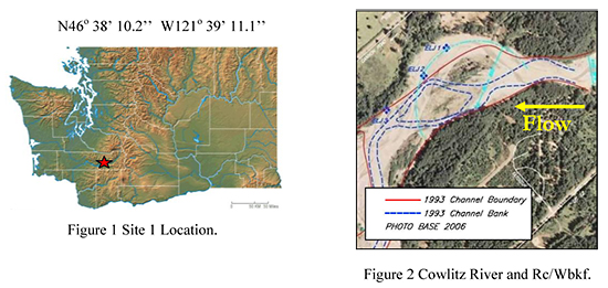
Previous to installation, rapid lateral recession into private property occurred due to damages from the fourth highest flood of record: LP III- 32,900cfs – 25Q. The QBKF (bank full discharge) at USGS Gage Packwood is approximately 9000cfs (1.1 to 1.2 return intervals). The Site 1 received post construction flood flows. The floods Qs between 1996 and 2002 ranged from 15,800cfs (1.9Q) in 1998 to 30,020cfs (20Q) in 1996 – just five weeks after construction. Two of the three ELJs were lost in 1999. The third ELJ was gone by 2002 with the exception of a few large wood members. The landowner estimated a loss of 7 acres with 300 feet of lateral recession since construction in 1996. The Rc/Wbkf is 1.9ft/ft (Figure 2). Meander turns with tortuosity values of Rc/Wbkf less than 2.5ft/ft are susceptible to extreme near-bank shear – the lower the value-the tighter the meander bend. Figure 3 shows the right bank of the Cowlitz several hundred feet behind the 1997 stream bank.
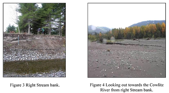
Figure 4 is a view from the right stream bank. Bedload transport and aggradation remain as concerns at Site 1. The stream bank stratigraphy is composed of lateral accretion with fine textured soil over vertical accretion-course gravel texture. Sand-sized matrix material and finer layers were washed out of gravel strata causing that unit to slough off, which undermines the overlying finer textured unit. The overlying finer-textured material has more shear strength. There is a difference in the shear strength of the finer-textured materials near the top of the bank. See the stream bank in Figure 3 behind the blue and white global probe velocity meter.
Site 2 – Cispus River on USFS Land-Figure 5: Previous to installation, stream bank erosion and lack of salmonid habitat were primary concerns for the USFS. USFS road 23 and USFS road 28 bridge crossing at the Cispus were at risk. ELJs were constructed at three principle sites referred to A, B, and C. Sites B and C were constructed in 1999 and Site A was constructed in 2001. Site A lost ELJ A1. Engineered log jam A2 is partially gone.
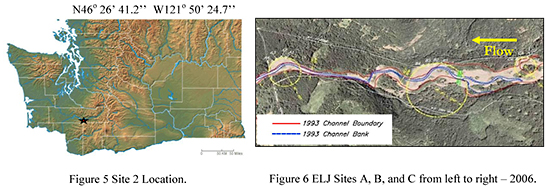
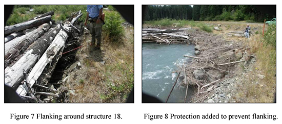
Between 1999 and 2006, Site 2 received four post project floods from 6440cfs 2.3QBKF to 14800cfs 19QBKF. The bank full Q at the Yellow jacket USGS gage for 11 years of record is estimated to be 3500 to 4000 cfs. There are 12 ELJs composed of 1400 logs that were constructed in 1998 and 1999. All ELJs were located on the right bank of the Cispus. These ELJs were the passive anchor type with no pylons or cable used. The four ELJs at site C are not connected to the main channel at lower flows. Scours and flanking in the vicinity of the stream bank and keys were present at Sites A and B as shown in Figure 7 and Figure 8.
Site 3 North Fork of the Stillaquamish: The North Fork of the Stillaquamish is located in Northwestern Washington (Figure 9). ELJs #1 through #4 located on the North Fork of the Stillaquamish were constructed in 1998 near the “C” Bridge on river mile 21. Three left bank ELJs, #6 through #8, were constructed upstream from the first five on river mile 22 in 1999. ELJs #6–#8 were constructed with cable only at the front of the key log members next to the sill log. The ELJs on the North Fork of the Stillaquamish were implemented with the passive anchor approach with a minimal amount of cable for maintenance.
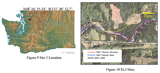
One of the primary objectives for ELJ #1 was to trap wood that was continuously piling up at the C-Post bridge, which is located immediately downstream. There was a large pool located just beneath the C-Post bridge where poaching was a concern. Shortly after installation in 1998, ELJ #1, located on the left bank immediately above the C Post Bridge, had one of the deepest pools with one of the highest populations of salmon on the North Fork of the Stillaguamish. The pool was measured to be 4–5 meters deep. In 2003 as the North Fork began to shift left of the center bar – with apex bar jam #2 the rivers alignment was more directly in-line with the C-Post Bridge. The side channel with ELJ #1 began to fill, and eventually by 2005 the jam was completely filled with finer textured alluvium (Figure 11 and Figure 12).
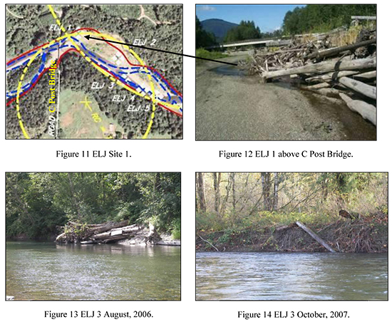
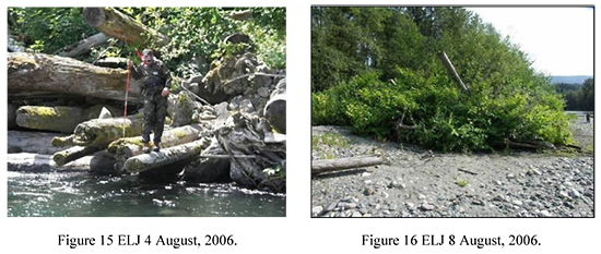
In 2006 ELJ #3 was washed out as depicted in Figure 13 and Figure 14. ELJs #4 and #5 are still present. ELJ #4 was one of the better examples of a structure that has continuously provided both stream bank protection and an excellent deep summer pool for adult salmonid refugia with an excellent tail-out glide for spawning. The Rc/Wbkf at ELJ #4 is slight at 6.7ft/ft. In August of 2006, twelve adult Chinook salmon were counted at ELJ #4 (Figure 15).
ELJs #6, #7, and #8 were located on the left bank at the top of the point bar near river mile 22. The opposite side bank is highly erosive. Since implementation, Site 3 of The North Fork of the Stillaquamish has received at least seven floods above bank full discharge ranging between 20,300cfs and 44,000cfs at the USGS gage near Arlington. Bank full discharge is 13,000 to 14,000cfs at the USGS gauge 12167000.
Gauge 12167000 has a 262m2 catchment size. Site 3 has a 115m2 catchment size. Bank full discharge at Site 3 is estimated to be approximately 6,000 to 7,000cfs. The floods are estimated to be proportionally larger as indicated by the USGS Gauges below and above Site 3. The 2003 flood at Arlington was estimated to be a 43-year event using a Log Pearson Type III analysis.
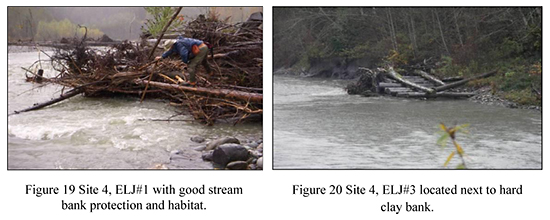
Site 4 South Fork of the Nooksack: Site 4, South Fork of the Nooksack, is located in Northwestern WA ten miles from the Canadian Border (Figure 17 and Figure 18).
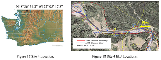
ELJs #1–#6 were installed in 2000 between river mile 19.7 and 21.0 on the South Fork of the Nooksack. The ELJs on the South Fork were all present in 2007. These ELJs were the passive anchor type (Figure 19). The tortuosity was very slight on all structures. The pattern of convergent flow resulting in structural flanking was not observed on five of the six ELJ structures assessed. ELJ #3 did have loose log members at the top of the structure and some slight bank erosion at the start of the structure (Figure 20). Older, compacted lacustrine bed material is present along stream banks and below coarser alluvial armor. Bed and local stream bank armor is high in glacial and glacial-fluvial transported granitic material that is erratic in this watershed. The channel is likely to be a paleo-channel formed in a higher elevation fluvial geomorphic regime. These conditions are optimal for improved bed and bank stability. This site location and social-economic landscape setting appear to be ideal for engineered log jams designed to address both stream bank stability and fish habitat improvement. Several floods ranging from 7650cfs to 13500cfs have occurred since implementation. Bank full discharge is estimated to be between 4250cfs and 6250cfs.
Site 5 Elwha River: Site 5 is located at river mile 1.9 on the Elwha River on the Olympic Peninsula of Washington State. The Elwha River is a large fresh water outlet to the Strait of Juan de Fuca (Figures 21 and 22).
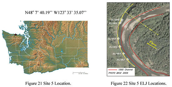
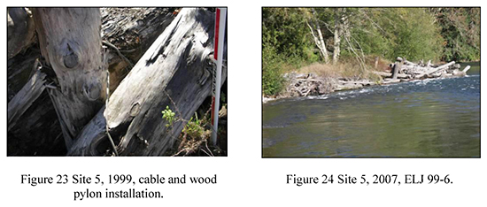
Prior to installation, the Elwha River was laterally migrating toward the left bank (Figure 22). Excessive stream bank loss was a major concern by the Elwha Tribe and property owners. Five of the six ELJs installed at Site 5 on the Elwha have achieved the principle objectives of fish habitat improvement and stream bank stability. The anchor style at Site 5 is the rigid anchor approach incorporating the use of cable and wood pylons with no rock (Figure 23). In the fall of 2007, ELJ 99-4 collapsed and shifted into 99-6 (Figure 24). During site assessments in 2006 and 2007, nearly a dozen large Chinook were observed using all six structures. Five of the six structures maintained deep pools with large wood members as cover components. The tortuosity is relatively tight at 2.5ft/ft. The Log jams were triangular deflector shape, which is different than all the other ELJ sites appraised in 2006 and 2007.
The Elwha River ELJ Site 5 has had several out-of-bank floods since implementation ranging from 19,700cfs to 29,700cfs in 2003 (USGS Gauge 12045500). QBKF estimate is 8000cfs. The Elwha River has been deprived of natural bedload transport into this site due to the construction of a two large dams upstream, the Elwha and Glines Canyon. The Elwha Dam was 93 years old in 2006. Site 5 is located approximately four miles downstream from the lower Elwha Dam.
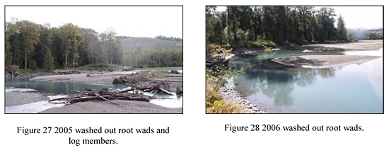
Site 6 Upper Hoh River Site: Site 6 is located on the Olympic Peninsula. ELJs #1, #2, and #3 were constructed in 2003 at Site 6, in part, as mitigation for rip-rap constructed to protect the stream bank toe that supports the Upper Hoh Rain Forest Road (Figure 25 and Figure 26). Site 6 ELJs were constructed with a passive anchor technique. The principle objectives were fish habitat and stream bank protection. At 1.5 ft/ft, the tortuosity at Site 6 was the tightest of all sites assessed in this post project appraisal (Figure 27). The near bank shear on the cut-bank side at this site was extreme.
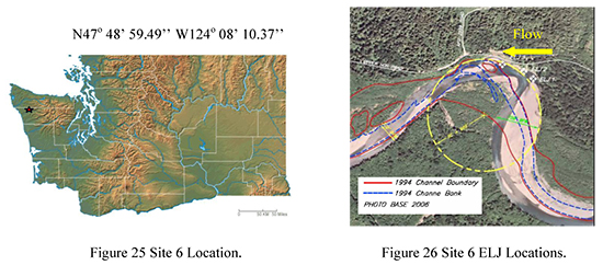
The implementation cost for Site 6 was $850,000 for the three ELJs. The ELJs were washed out in 2003 when a 25Q flood occurred in October 2003 as depicted in Figure 27 and Figure 28. Scour depths, permit restrictions, buoyancy and site location were all identified concerns at Site 6.
RESULTS: STAGE 1 POST-PROJECT APPRAISAL
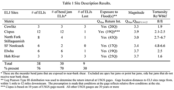
As of March 2008, of the 38 evaluated ELJs, 76% are still present. Of the 38 ELJs evaluated, 30 meander bend jams (MBJs) were built directly into the stream bank for protection. Seventy percent of the MBJs are still present of which two are at risk. The MBJs are at risk because of the flanking pattern, significant log shift and log-mass reduction, and continued convergent flow into the upstream side at the key between the stream bank and wood structure.
Table 1 is a summary of the results of the site descriptions. Not included in this table are four more bend jam ELJs observed that are showing similar patterns of instability to those that have been lost. The tortuosity of ELJs on the Cowlitz, Upper Hoh, and Elwha is considerably sharp. The sites with tortuosity values below 2.5ft/ft are more susceptible to flanking and loss. The South Fork of the Nooksack and Elwha Rivers had the best match between stated objectives and results.
CONCLUSION
The IDT identified significant concerns that impact the life expectancy of the ELJs analyzed in this post project appraisal:
1. Rc/Wbkf is the curvature tightness of turn and associated with increased shear in the near-bank area on meander bend log jams. Flow convergence into the key of meander-bend-style log jams on tight radius of curvatures (tortuosity) below Rc/Wbkf values of 2.4–2.6 are significant. Stability components, such as additional log pylons, deflection angle logs, and so forth, are designed to address this concern and should be considered on ELJ bend jam sites, especially in socioeconomic settings where erosive meander adjustments are located next to infrastructure that needs to be protected. In areas designated as a meander migration free corridor, there can be less emphasis on this stability concern.
2. The Height of log structures relative to bank full Q elevation and the associated floodplain entrenchment characteristics are impacted by the intensity of flow convergence on the log structure key at various flood stages. In locations like Site 6, where the curvature tightness has a low value (tight curve) and the bank height of the floodplain is high relative to channel formative discharge (bank full discharge), ELJs are at exceptional risk of failure. Stability augmentations should be considered.
3. During construction, alluvial fill was placed on numerous log structures to counter-act buoyancy of wood. The early loss of the alluvial fill due to high stage flows, bank full Q and above, leaves log jams more susceptible to failure. Building ELJs higher to create greater mass to counter-act buoyancy works to a point; however, flood flows, which are frequent on the West Slope of the Cascades, will impose buoyant forces on the log members located higher on the ELJs as their buoyant properties come in contact with flows.
4. The kind of bed material available in the channel to locate footers is important. Footers located in clay-type beds, such as older compacted lacustrine bed material on the Site 4 South Fork of the Nooksack, offer an important and good stability component for the ELJ.
ELJ studies (Pess et al., 2007) have documented improvement in other aspects of stream restoration relevant to fish habitat, macro-invertebrate response, and particle size distribution. For example, on the Elwha, finer gravels have deposited on bars associated with ELJs. Finer-grained bed material has been lacking due to upstream impediment by dams. Mean total invertebrate densities are significantly greater on wood than on cobble in the same reach. Juvenile fish densities were greater on ELJ reaches vs. non-ELJ reaches. Pess et al. (2007) found that the increase habitat complexity of ELJs has resulted in improved salmonid species richness for both juveniles and adults. Engineered Log Jam technology has improved over the last ten years. ELJs can be valuable tools and are a significant contribution to salmonid habitat and lateral, horizontal, and longitudinal profile aquatic assemblages. However, additional structural augmentations are needed to improve their longevity as an intact structure when stream bank protection and local salmonid habitat is specified as primary objectives. Their application in some socioeconomic landscape settings outside of meander migration-free zones should be more carefully scrutinized. Bed load transport capabilities through ELJ sites need additional morphometric-based studies pre- and post- project with data to understand ELJ impacts on aggradation. A better understanding of the hydraulic geometry and floodplain dimensions at ELJ sites will aide in understanding bed load transport capabilities. ELJs placed on meanders with tight radius of curvatures, especially below 2.5ft/ft, are considerably more prone to loss than those located on a gentler wavelength. This observation should be of considerable interest to stream designers who will build structures that have stream bank protection as an objective. Augmentations, such as wood pylons with a securing mechanism such as large pins and cables, have a higher potential for stream bank stability success.